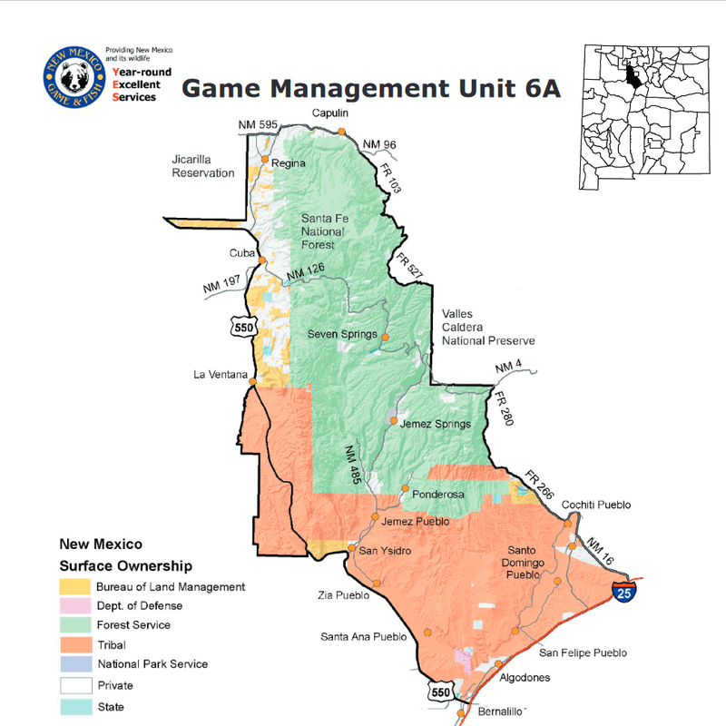
GMU 6A: Starting at the junction of interstate 25 and US 550 at Bernalillo and running northwest and west along US 550 past San Ysidro to it’s intersection with the boundary of the Zia Indian Reservation, then south, west, and north along the Zia Reservation boundary of the Jemez Indian Reservation, then west, north, and east along Jemez Indian Reservation boundary to it’s intersection with US 550 near La Ventana, then north and west along US 550 to it’s intersection with the south boundary of the Jicarilla Apache Indian Reservation, then east along the south boundary of the Jicarilla Apache Indian Reservation and north along it’s east boundary to it’s intersection with NM 595, then east along NM 595 to it’s junction with NM 96, then east along NM 96 to it’s junction with forest road (FR) 103, then south along FR 103 to it’s junction with FR 117, then south along FR 117 to it’s junction with FR 527 (Pipeline road), then east along FR 527 to it’s junction with the west boundary of the Valles Caldera National Preserve, then south and east along the boundary of the preserve to it’s junction with FR 280 and NM 4, then south along FR 280 to it’s junction with forest trail (FT) 140, then south along FT 140 to Peralta creek, then south and east along Peralta creek to it’s junction with FR 266, then south and east along FR 266 to it’s junction with NM 16, then along NM 16 to it’s junction with I-25, then south and west along I-25 to it’s junction with US 550 at Bernalillo.